New updates for Austin’s Light Rail are coming soon! Learn more about our upcoming open house on March 21 and what’s next for Project Connect: Learn more

PROJECTSLIGHT RAIL

Artist conceptual rendering of light rail on 'The Drag'

What is Light Rail? — Light Rail is an electric train system used in metropolitan areas. Light rail trains can travel at street level, on elevated structures or underground.

The “light” in light rail refers to its smaller size, compared to larger trains that ride on more traditional tracks, such as Austin’s existing Red Line commuter rail. Light rail is part of the overall transit network, connecting people to key destinations where they live, work and play.

What's next for Austin Light Rail?

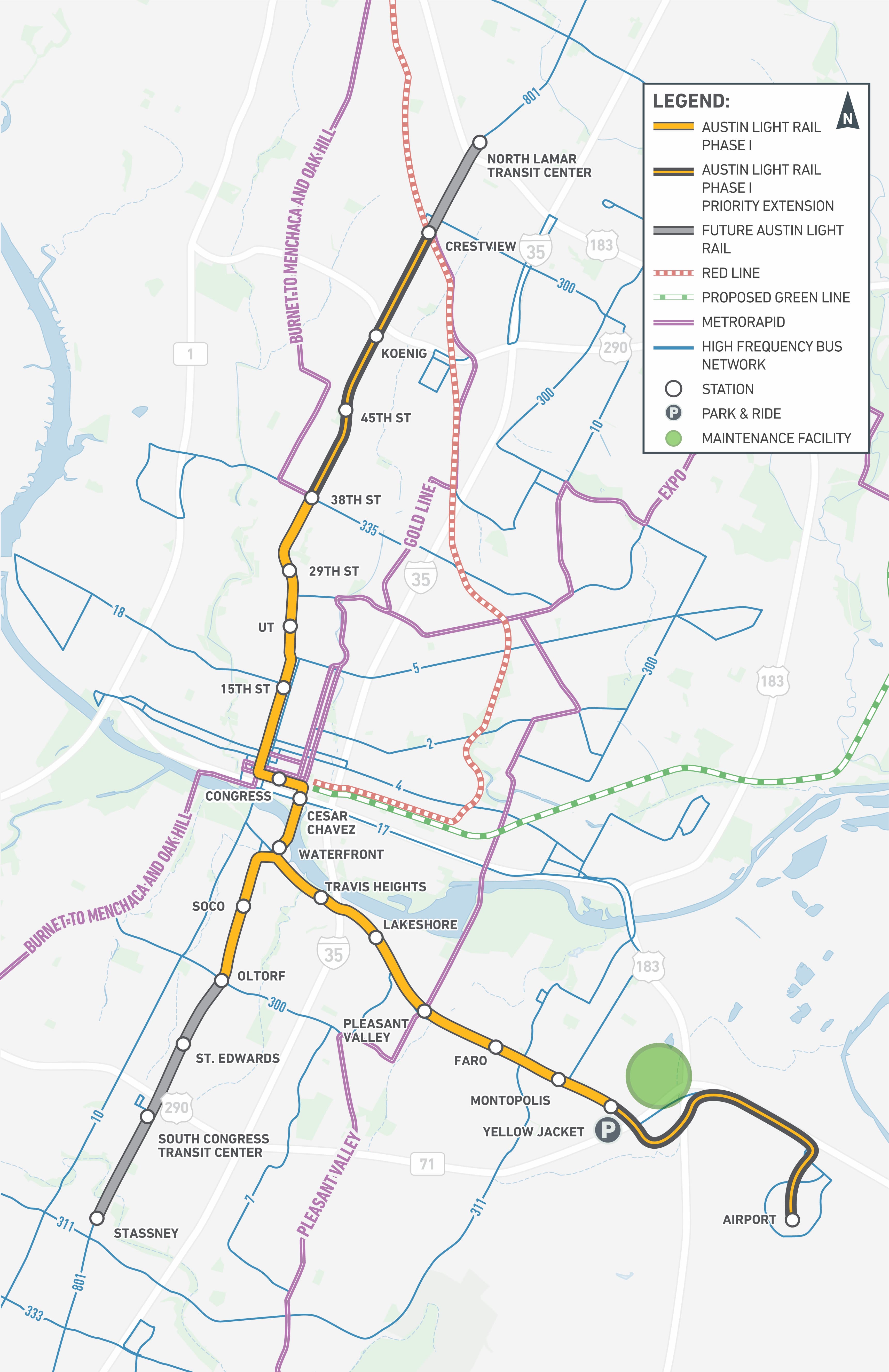
The Austin Transit Partnership (ATP)—the independent entity tasked with implementing Project Connect—appreciates the tremendous amount of input we have received from Austinites as we work to expand and improve our public transportation network. Read ATP's staff recommendation for the initial phase of light rail below.

Read Report

Download a digital, PDF version of this report here.

Thank you for all your great feedback, Austin!

May 2, 2023 concluded the Spring 2023 phase of public engagement for Austin’s core light rail system. The feedback has been analyzed and collected, and you can read the report here.

Read Report

You may continue to learn about Austin Light Rail from this webpage and through the self-guided Virtual Open House (VOH). For additional opportunities to provide feedback on light rail options before the joint partnership meeting on June 6, check the Get Involved calendar at the bottom of this page.


What is ATP?

The Austin Transit Partnership (ATP) was officially created by the City of Austin and CapMetro in December 2020 as the independent entity, accountable and responsible for the financing, design, construction, and overall implementation of Project Connect. ATP’s charge is to deliver on the voters’ transit vision in partnership with the community — and in a way that embeds equity, sustainability, and transparency as overarching priorities. ATP is driven by data, which includes community input, and is committed to meeting voters’ goals and honoring Austin’s values.


Austin Light Rail Options for Community Feedback

The below maps and descriptions show different options for Austin’s Light Rail that are currently being considered for the core light rail system. Take the self-guided tour of these options from the Virtual Open House (VOH). Please note that you may learn about these options but may not provide feedback through the VOH at this time. If you would like to contact us, please email input@atptx.org. More information will be shared soon.

Download Light Rail Options Fact Sheet (English)

Download Fact Sheet

Descargar hoja informativa sobre las opciones del tren ligero (Español)

Descargar Hoja Informativa

Description

  • On-street from 38th Street on Guadalupe Street to Oltorf Street on South Congress Avenue and Yellow Jacket Lane on East Riverside Drive​
  • Potential to extend endpoints to 45th Street to the north or St. Edwards Drive to the south​
  • Lady Bird Lake crossing options at South 1st Street or Trinity Street​


Light rail statistics graphic for on-street 38th to Oltorf to Yellow Jacket option. Option includes 9.4–9.8 miles of rail, 14-15 light rail stations, serve 30,000 average daily riders and 20,250 number of affordable subsidized housing units.

Light rail option 1: on-street: 38th to Oltorf to Yellow Jacket map

Description

  • On-street from North Lamar Transit Center on North Lamar Boulevard to Pleasant Valley Road on East Riverside Drive​
  • Lady Bird Lake crossing options at South 1st Street or Trinity Street


Light rail statistics graphic for on-street North Lamar to Pleasant Valley option. Option includes 9.6–9.8 miles of rail, 13-14 light rail stations, serve under 40,000 average daily riders and 20,250 number of affordable subsidized housing units.

Light rail option 2: on-street: North Lamar to Pleasant Valley map

Description

  • On-street from 29th Street on Guadalupe Street to east of Yellow Jacket Lane on East Riverside Drive​
  • Mainly elevated from SH 71 to Austin-Bergstrom International Airport​
  • Lady Bird Lake crossing at Trinity Street


Light rail statistics graphic for on-street 29th to Airport option. Option includes 10.1 miles of rail, 13 light rail stations, serve under 30,000 average daily riders and under 20,000 number of affordable subsidized housing units.

Light rail option 3: on-street: 29th to the Airport map

Description

  • On-street from 29th Street on Guadalupe Street to south of 8th Street
  • Elevated from south of 8th Street on Guadalupe Street to east of Auditorium Shores with elevated stations
  • On-street from east of Auditorium Shores to Oltorf Street on South Congress Avenue and Yellow Jacket Lane on East Riverside Drive
  • Lady Bird Lake crossing at South 1st Street


Light rail statistics graphic for partial elevated 29th to Oltorf to Yellow Jacket option. Option includes 8.7 miles of rail, 13 light rail stations, serve under 30,000 average daily riders and under 20,000 number of affordable subsidized housing units.

Light rail option 4: partial elevated: 29th to Oltorf to Yellow Jacket map

Description

  • Underground from 20th Street on Guadalupe Street (UT) to south of 8th Street with one underground station​
  • Elevated from south of 8th Street on Guadalupe Street to east of Auditorium Shores with elevated stations​
  • On-street from east of Auditorium Shores to Yellow Jacket Lane on East Riverside Drive​
  • Lady Bird Lake crossing at South 1st Street


Light rail statistics graphic for partial underground UT to Yellow Jacket option. Option includes 6.6 miles of rail, 10 light rail stations, serve under 20,000 average daily riders and under 19,000 number of affordable subsidized housing units.

Light rail option 5: Partial Underground: UT to Yellow Jacket map

Download a Light Rail Open House Fact Sheet (English)(PDF)

Descargar Hoja Informativa sobre las Opciones del Tren Ligero (Español)(PDF)


Frequently Asked Questions (FAQs)

You ask, we answer. Visit our Frequently Asked Questions (FAQs) for a few questions we get the most. We update these regularly from what we hear in the community so check back often! If you don't see what's on your mind, send us an email at input@atptx.org.

Read the Light Rail FAQs

Original Orange Line - 2020

The proposed Orange Line project is a 20-mile light rail transit (LRT) corridor that would travel along Lamar Boulevard and Congress Avenue from the Tech Ridge Park & Ride at Howard Lane south to Slaughter Lane.

See Archive

Original Blue Line - 2020

The proposed Blue Line Project is an 8.2-mile light rail transit (LRT) corridor that would operate from Republic Square in downtown Austin to the Austin-Bergstrom International Airport (AUS) .

See Archive